Is Assab part of Ethiopia, as a map displayed by Ethiopian army commanders suggests?
The claim
A map on a plaque held up by Ethiopian army officers at a Special Operations Command graduation, showing Ethiopia's territory extending to the Red Sea coast at Assab, and Eritrea's Southern Red Sea region shaded as part of Ethiopia.
Our finding
Case AR-2026-001Verdict
False
A map displayed by Ethiopian army officers appears to show Eritrea's port of Assab and its Southern Red Sea region as part of Ethiopia. They are Eritrean territory. The border was fixed by an international commission in 2002 under an agreement both countries signed, Ethiopia formally accepted that ruling in 2018, and Ethiopia's prime minister has himself spoken of “regaining” Assab.
What the photograph shows
A photograph circulating since at least January shows three officers in Ethiopian army uniform holding up a framed plaque at an outdoor ceremony . The plaque reads, in Amharic, “Special Operations Command Headquarters, we thank you”. It carries the command’s emblem and a map of the Horn of Africa. A banner behind them refers to the fourth round of the Tsenat course, a commando training programme.
The Horn Frequency, a newsletter covering the region, reported on 4 January that the army had displayed a map at the fourth-round graduation of its special forces that “appears to incorporate Assab” .
What the map shows
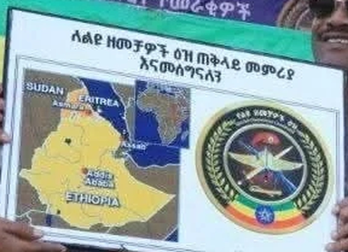
On the map, Ethiopia is shaded yellow. In the enlarged image, the yellow area appears to run to the Red Sea coast at Assab, which is labelled. Only the northern part of Eritrea, around Asmara, is shaded separately . The long coastal strip that forms Eritrea’s Southern Red Sea region, including Assab, appears inside the yellow area, as part of Ethiopia.
The photograph is small, and the map occupies only a few hundred pixels of it. Our reading matches The Horn Frequency’s, but we have not found a higher-resolution copy.
Whose territory is Assab?
Assab and the Southern Red Sea region are part of Eritrea.
The border between the two countries was settled by the Eritrea–Ethiopia Boundary Commission, which both governments agreed to set up under the Algiers Agreement of December 2000. They committed in advance to treat its decision as final and binding. The Commission delivered its decision on 13 April 2002 , and the UN Security Council welcomed it as “final and binding” .
In June 2018, Ethiopia’s ruling coalition announced that Ethiopia would “fully accept” the Algiers Agreement and the Commission’s ruling .
Ethiopia’s own prime minister does not claim Assab is Ethiopian today. In September 2025, Abiy Ahmed told the state broadcaster EBC that it was “a matter of time” before Ethiopia regained the port, and that “the Red Sea was part of Ethiopia before thirty years ago” .
Eritrea’s position
Eritrea’s government rejects any Ethiopian claim to its coast. In an editorial published by the Ministry of Information on 9 October, in Tigrinya, it describes its borders as “a matter of sovereignty and territorial integrity, bound by international law and treaties”, and says “Eritrea’s sovereign territory is bounded by blood and by law” . The translation is ours.
Our verdict
False. A map presented as showing Ethiopia, displayed by officers of Ethiopia’s Special Operations Command, appears to include Assab and Eritrea’s Southern Red Sea region within Ethiopia. That territory belongs to Eritrea under a boundary ruling both countries agreed in advance to accept, which the UN Security Council called final and binding, and which Ethiopia formally accepted in 2018.
Exhibits
- A
Image
The photograph: officers in Ethiopian army uniform hold a plaque reading “Special Operations Command Headquarters, we thank you” (in Amharic), with a map of the region and the command's emblem. The banner behind refers to the fourth round of the Tsenat course.
adulis-review.pages.dev ↗ - B
Image
The map on the plaque, enlarged four times from the photograph. Ethiopia is shaded yellow; the yellow area appears to reach the Red Sea coast at Assab, while only the north of Eritrea is shaded separately.
adulis-review.pages.dev ↗ - C
Report
The Horn Frequency, 4 January 2026: reports that the army displayed a map that “appears to incorporate Assab” at the fourth-round graduation of its special forces, attended by Lt. Gen. Shuma Abdeta, commander of the Special Operations Command.
thehornfrequency.substack.com ↗ - D
Statement
UN Security Council press statement SC/7363, 17 April 2002: welcomes the Eritrea–Ethiopia Boundary Commission's decision of 13 April 2002, “which is final and binding”.
press.un.org ↗ - E
Document
Eritrea–Ethiopia Boundary Commission case record at the Permanent Court of Arbitration, including the 2002 delimitation decision.
pca-cpa.org ↗ - F
Report
Africanews, 5 June 2018: Ethiopia's ruling coalition announces that Ethiopia “will fully accept” the 2000 Algiers Agreement and the Boundary Commission's ruling.
africanews.com ↗ - G
Statement
The Reporter (Ethiopia), 6 September 2025: Prime Minister Abiy Ahmed tells state broadcaster EBC it is “a matter of time” before Ethiopia regains the port of Assab, and that “the Red Sea was part of Ethiopia before thirty years ago”.
thereporterethiopia.com ↗ - H
Statement
Eritrea's Ministry of Information, editorial published as a press release on shabait.com, 9 October 2026 (in Tigrinya). Our translation of the key passage: “It is a matter of sovereignty and territorial integrity, bound by international law and treaties. Eritrea's sovereign territory is bounded by blood and by law.” Archived at the Wayback Machine on 9 October 2026.
shabait.com ↗
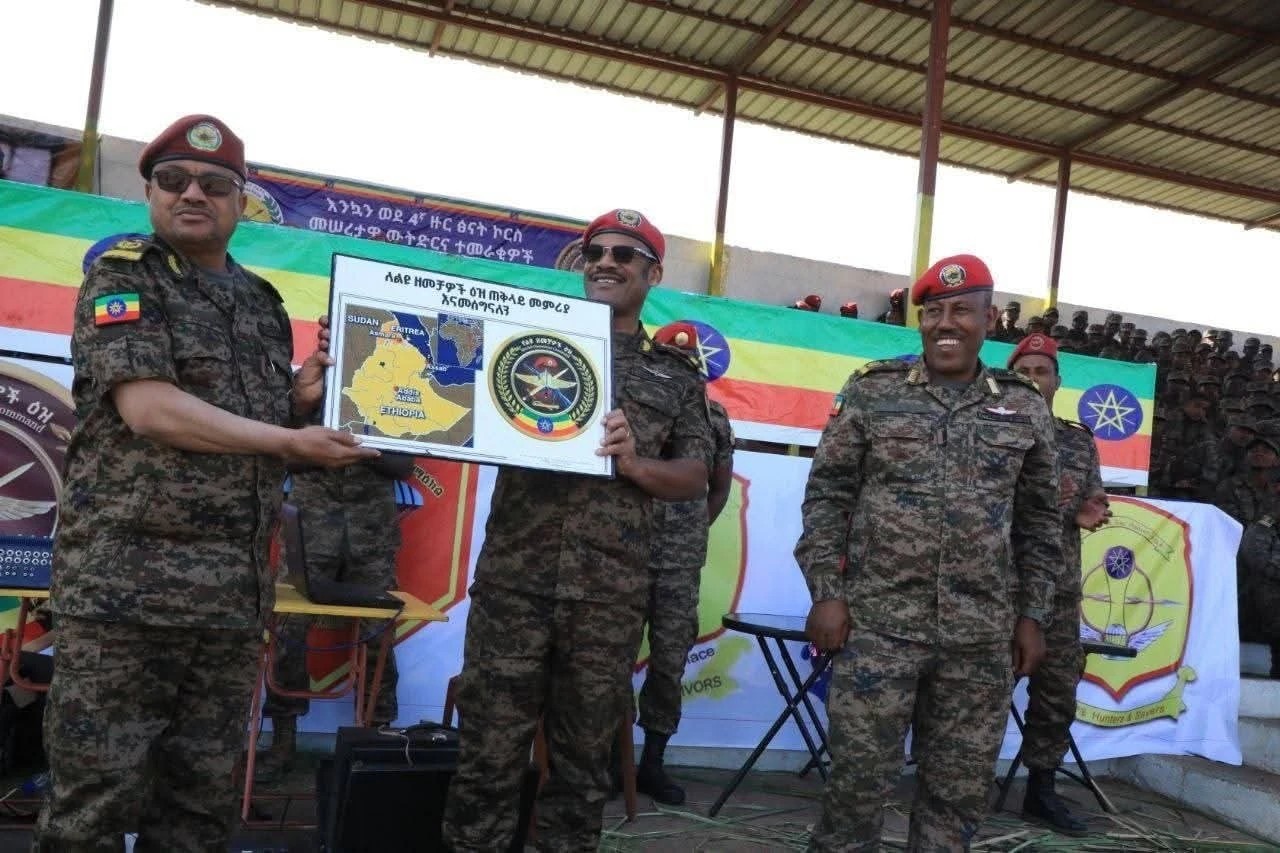
The photograph: officers in Ethiopian army uniform hold a plaque reading “Special Operations Command Headquarters, we thank you” (in Amharic), with a map of the region and the command's emblem. The banner behind refers to the fourth round of the Tsenat course.
The map on the plaque, enlarged four times from the photograph. Ethiopia is shaded yellow; the yellow area appears to reach the Red Sea coast at Assab, while only the north of Eritrea is shaded separately.
The Horn Frequency, 4 January 2026: reports that the army displayed a map that “appears to incorporate Assab” at the fourth-round graduation of its special forces, attended by Lt. Gen. Shuma Abdeta, commander of the Special Operations Command.
UN Security Council press statement SC/7363, 17 April 2002: welcomes the Eritrea–Ethiopia Boundary Commission's decision of 13 April 2002, “which is final and binding”.
Eritrea–Ethiopia Boundary Commission case record at the Permanent Court of Arbitration, including the 2002 delimitation decision.
Africanews, 5 June 2018: Ethiopia's ruling coalition announces that Ethiopia “will fully accept” the 2000 Algiers Agreement and the Boundary Commission's ruling.
The Reporter (Ethiopia), 6 September 2025: Prime Minister Abiy Ahmed tells state broadcaster EBC it is “a matter of time” before Ethiopia regains the port of Assab, and that “the Red Sea was part of Ethiopia before thirty years ago”.
Eritrea's Ministry of Information, editorial published as a press release on shabait.com, 9 October 2026 (in Tigrinya). Our translation of the key passage: “It is a matter of sovereignty and territorial integrity, bound by international law and treaties. Eritrea's sovereign territory is bounded by blood and by law.” Archived at the Wayback Machine on 9 October 2026.
Record of events
| 2000-12-12 | Eritrea and Ethiopia sign the Algiers Agreement, committing in advance to accept the Boundary Commission's decision as final and binding. |
|---|---|
| 2002-04-13 | The Eritrea–Ethiopia Boundary Commission delivers its decision. |
| 2002-04-17 | The UN Security Council welcomes the decision as final and binding. |
| 2018-06-05 | Ethiopia announces it fully accepts the Algiers Agreement and the Commission's ruling. |
| 2025-09-06 | Ethiopia's prime minister says it is a matter of time before Ethiopia regains Assab. |
| 2026-01-04 | Claim published by Ethiopian National Defense Force. |
| 2026-10-09 | Eritrea's Ministry of Information publishes an editorial describing its territory as bound by international law and treaties. |
| 2026-10-09 | This review published. |